
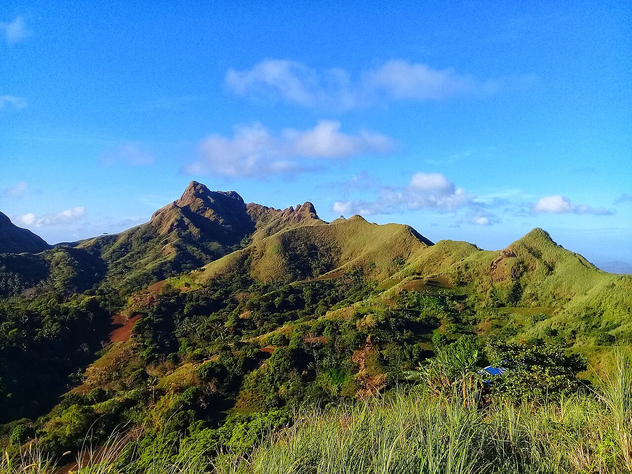
Mount Batulao stands like a jagged green crown just a few hours south of Manila, its ridgeline cutting dramatic silhouettes against the Batangas sky. Located in Nasugbu, Batangas, this 811-meter mountain has earned a reputation as the perfect stepping stone for beginners—challenging enough to feel like a real accomplishment, but forgiving enough that first-time hikers won’t find themselves completely overwhelmed.
The mountain’s rolling ridges and open grasslands offer some of the most photogenic hiking in the Philippines, with panoramic views stretching from Taal Lake to the Batangas coastline. It’s the kind of place where every turn reveals another Instagram-worthy vista, though honestly, the photos never quite capture the feeling of standing on those exposed ridges with the wind in your face and endless green mountains rolling out in all directions.
Mount Batulao is just one of several trails we cover in our complete guide to Top Day-Hiking Trails in the Philippines for Beginners, but there’s something special about this particular mountain that keeps drawing hikers back. Maybe it’s the accessibility—you can be hiking within hours of leaving Manila. Or perhaps it’s the perfect balance of challenge and reward that makes it such an ideal training ground for bigger adventures ahead.
Why Choose Mount Batulao for Your Next Adventure?
Accessibility is honestly one of Mount Batulao’s greatest strengths. At just 2-3 hours from Manila via SLEX and the Tagaytay-Nasugbu road, it’s close enough for a proper day hike without requiring vacation days or elaborate travel arrangements. The proximity means you can leave Manila at 4 AM and still be back for dinner—assuming you don’t get tempted by Tagaytay’s famous bulalo restaurants on the way home.
The mountain offers a moderate challenge that builds confidence without being overwhelming. Rated 4/9 on the Philippine difficulty scale, it sits right in that sweet spot where beginners feel accomplished and experienced hikers can use it for training or casual weekend adventures. The trail teaches essential hiking skills—pacing yourself on long ascents, navigating rocky terrain, dealing with exposed ridges—without throwing you into anything genuinely dangerous.
Those rewarding views are what really seal the deal. From the summit, you get 360-degree panoramas taking in Taal Lake, the Batangas coastline, and the surrounding mountain ranges. On clear days, you can see all the way to Pico de Loro and even catch glimpses of Balayan Bay. It’s the kind of payoff that makes every upward step feel worthwhile.
Mount Batulao also serves as excellent training for harder climbs. Many hikers use it to prepare for more challenging mountains like Mount Pulag or longer multi-day adventures. The exposed ridges and steady climbs build the leg strength and cardiovascular fitness that bigger mountains demand, while the relatively short duration means you won’t be completely wiped out if you’re still building your hiking fitness.
If you’d like a lighter climb to start with, try nearby Mount Talamitam, another Batangas favorite that’s even more beginner-friendly and often combined with Batulao for twin-peak adventures.
Mount Batulao at a Glance: Quick Facts
| Detail | Information |
|---|---|
| Location | Nasugbu, Batangas |
| Elevation | 811 meters above sea level |
| Difficulty | 4/9 (beginner to moderate) |
| Trail Length | ~12 kilometers round trip |
| Duration | 4-6 hours |
| Best Season | Dry months (November – May) |
| Registration Fees | ₱20-30 per checkpoint |
| Guide Requirements | Optional but recommended |
| Camping | Available at designated sites |
The mountain features two main trails—the New Trail and Old Trail—each offering different experiences and difficulty levels. Most day hikers take the New Trail up for its gentler ascent and better scenery, then loop back via the Old Trail for variety, though some prefer to stick with just one route depending on their comfort level and time constraints.
Registration fees vary depending on which trail you choose and whether you do a traverse. Expect to pay around ₱20-30 at each checkpoint, with the traverse requiring registration at both trail systems. These fees support local communities and trail maintenance, so they’re well worth the modest cost.
Local guides are available and strongly recommended for first-time visitors, especially if you’re hiking alone or unfamiliar with the area. Guide fees typically run around ₱500 per group, and experienced guides like Kuya Val (0920-330-5172) can make the difference between a good hike and a great one. Book guided tours online for convenience and peace of mind, particularly if you’re coordinating transport and logistics for a group.
If you’re traveling to Cebu instead, consider the quick trek up Osmena Peak for a completely different but equally rewarding mountain experience.
Getting to Mount Batulao
From Manila by private car, the route is straightforward: take SLEX to the Tagaytay-Nasugbu Highway, then continue until you reach KC Hillcrest Golf Course (formerly Evercrest Hotel), which serves as the primary jump-off point. The drive takes approximately 2.5 hours in good traffic, though weekend traffic can extend that significantly. There’s ample parking available near the registration area, making it convenient for day hikers with their own transportation.
Public transport requires a bit more patience but is definitely doable. Take a DLTB bus from the Buendia terminal bound for Nasugbu—the first bus typically leaves around 3 AM, with fare around ₱120. Tell the driver to drop you at KC Hillcrest or the Mount Batulao junction. From the highway, you’ll need a tricycle ride to the actual trailhead, which costs around ₱30-100 per person depending on how far into the trail you want to be dropped off.
The tricycle option is worth considering—it can save you 30-45 minutes of walking on roads and get you closer to the actual hiking trails. Some tricycle drivers will take you right to the registration areas, while others stop at designated points where you’ll walk the remaining distance to the trailheads.
Van rentals and packaged tours often make the most sense for groups, especially first-time visitors. Many tour operators offer complete packages including roundtrip transport from Manila, guide fees, permits, and sometimes even meals. Trail Adventours, for example, offers packages starting around ₱2,400 per person with pickup from Manila. These packages eliminate the logistics hassle and often work out to reasonable value when you factor in all the included services.
The early morning departure times mean you’ll be traveling in the dark, but that’s actually preferable—you’ll beat both traffic and heat, arriving at the trailhead when conditions are most comfortable for hiking.
Trail Description: What to Expect on Mount Batulao
Trailheads and Starting Points
Mount Batulao offers two distinct trail experiences, each with its own character and challenges. The New Trail begins near KC Hillcrest Golf Course and is generally considered the more scenic and beginner-friendly option. It features wider paths, gentler gradients, and more rest stops with vendors selling refreshments. The Old Trail starts from a different point and is known for being more challenging, with steeper sections and more exposed ridges.
Most day hikers choose to do a traverse—taking one trail up and the other down—which provides variety and prevents the boredom of re-tracing your steps. The classic combination is New Trail ascending and Old Trail descending, though some hikers prefer the opposite for a more challenging ascent experience.
Registration happens at the beginning of whichever trail you choose. The process is straightforward—fill out basic information, pay the environmental fees, and receive a brief safety orientation. This is also where you’ll meet local guides if you haven’t already arranged one in advance.
The Ascent Experience
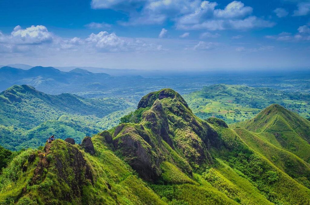
The hike begins through local communities and farmland before transitioning into the mountain’s signature grassland terrain. These rolling hills covered in tall grass create the iconic Batulao landscape that appears in countless hiking photos. The trail is well-defined, though it can get muddy after rain, so proper footwear with good traction becomes important.
As you gain elevation, the views gradually open up, revealing more of the surrounding Batangas landscape with each ridge you cross. The trail includes several scenic stops perfect for photography and rest breaks—take advantage of these, especially on hot days, as the exposed grasslands offer limited shade.
The gradient varies throughout the hike, with relatively gentle sections punctuated by steeper climbs. The most challenging parts typically come in the final approach to the summit, where the trail becomes rockier and steeper. Roped sections help with the most challenging parts, though basic scrambling skills come in handy.
Summit Views and Experience
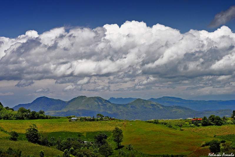
The summit of Mount Batulao delivers on its promise of spectacular 360-degree views. To the east, Taal Lake stretches out like a blue jewel set in green hills, with the distinctive cone of Taal Volcano rising from its center. Westward, the Batangas coastline shimmers in the distance, while the surrounding mountains create a dramatic backdrop in every direction.
The rocky summit area provides stable platforms for photos and rest, though it can get crowded on weekends and holidays. Early morning hikers often have the best experience, both for cooler temperatures and fewer crowds. The summit is also where many hikers first truly appreciate the mountain’s jagged ridgeline—looking back at the route you’ve just climbed reveals the dramatic landscape that makes Batulao so photogenic.
Safety considerations become important at the summit, particularly around the steeper rocky areas. The exposed location means strong winds are common, and the combination of rocks and wind requires careful footing. Take your time enjoying the views, but maintain awareness of your surroundings and avoid getting too close to cliff edges.
Descent Options
The loop hike option—ascending via New Trail and descending via Old Trail—provides the most complete Batulao experience. The Old Trail descent is steeper and more technical, requiring more attention to foot placement, but it offers different perspectives on the mountain’s terrain and typically takes less time than the ascent.
Some hikers prefer to return via the same trail they ascended, especially if they’re particularly tired or if weather conditions have deteriorated. There’s no shame in choosing the safer or more familiar option—the important thing is completing your hike safely.
The descent is where trekking poles really prove their worth, taking pressure off your knees and providing stability on loose or steep terrain. Good footwear with reliable traction becomes even more important going downhill, where slips are more likely and potentially more dangerous.
For similar trail variety and descent options, check our Mount Daraitan & Tinipak River guide for a mountain-and-river combination that offers completely different post-hike relaxation.
Things to See and Do Around Mount Batulao
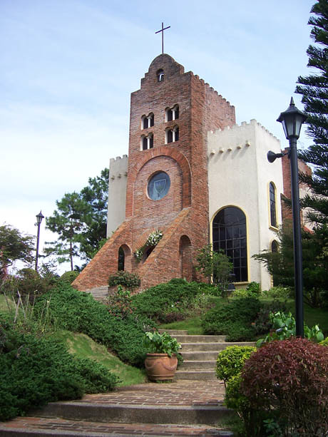
Caleruega Church, located just a few minutes from the Batulao trailhead, makes an excellent side trip either before or after your hike. This tranquil retreat center, built by the Dominican Order, offers beautiful gardens and peaceful architecture that provides a nice contrast to the rugged mountain experience. The church’s elevated location also provides lovely views of the surrounding Batangas countryside.
Tagaytay stopovers are practically mandatory for most Batulao hikers. The cool mountain air and famous bulalo restaurants provide the perfect way to celebrate your hiking achievement. Tagaytay’s ridge-top location offers spectacular views of Taal Lake and Volcano, and the town’s numerous restaurants serve hearty Filipino comfort food that tastes especially good after hours of hiking.
For those wanting to extend their mountain experience, overnight camping is available at designated sites along the trails. Camp 1 on the Old Trail is particularly popular, offering basic facilities including restrooms and shelter areas. The camping experience adds a completely different dimension to Batulao, with sunrise views from your tent and the chance to experience the mountain’s quieter, more contemplative side.
Local eateries along the trail and at the base provide opportunities to try regional specialties and interact with local communities. Don’t miss the buko juice vendors who set up at various points along the trails—fresh coconut water is incredibly refreshing and provides natural electrolytes that are perfect for hiking.
The barangay communities around Batulao offer glimpses into rural Filipino life, with friendly locals who are often happy to chat with visiting hikers. These interactions add cultural depth to the hiking experience and remind you that these trails pass through living communities, not just scenic landscapes.
Essential Packing List for Mount Batulao
Your day pack should be in the 20-30 liter range—large enough for water, food, and safety essentials without being unnecessarily bulky for a day hike. Look for something with padded straps and ideally a hip belt, as you’ll be carrying it for 4-6 hours. A pack with external water bottle pockets is particularly convenient for frequent hydration.
Footwear deserves careful consideration. While you don’t need heavy mountaineering boots, you do need something with reliable traction and ankle support. Trail running shoes or light hiking boots work well, provided they have aggressive tread patterns for the sometimes muddy and always varied terrain. Avoid brand-new shoes—break them in first to prevent blisters.
Clothing should account for the exposed, sun-drenched nature of most Batulao trails. Long sleeves in lightweight, UV-protective fabric help prevent sunburn while allowing cooling airflow. Avoid cotton in favor of synthetic or merino wool materials that wick moisture and dry quickly. A lightweight rain jacket is essential, as Philippine weather can change quickly.
Hydration is absolutely critical. Carry at least 2-3 liters of water per person—more if it’s particularly hot or if you’re a heavy sweater. Electrolyte tablets or sports drinks can help replace salts lost through sweating. Some hikers prefer hydration bladders for hands-free drinking, while others like bottles for easier monitoring of consumption.
Trekking poles are highly recommended, especially for the rocky sections and steep descents. They provide stability, reduce impact on knees, and can help clear vegetation or test footing on uncertain terrain. Lightweight, collapsible poles are ideal for day hiking.
Snacks and energy foods should focus on items that provide quick energy and are easy to eat on the trail. Energy bars, trail mix, dried fruit, and sandwiches all work well. Some hikers swear by local options like SkyFlakes crackers or dried mango for familiar, readily available trail fuel.
Sun protection cannot be overstated on Batulao’s exposed ridges. Sunscreen (SPF 30+), a wide-brimmed hat, and sunglasses are essential. The combination of altitude, reflection from grass, and extended exposure can cause severe sunburn even on partly cloudy days.
Safety essentials include a basic first-aid kit with bandages, pain relievers, and any personal medications. A whistle for emergencies, headlamp or flashlight (in case you’re out longer than expected), and cash for registration fees round out the safety considerations.
See our recommended beginner hiking gear checklist for specific product recommendations and more detailed packing guidance.
Safety Tips for First-Time Mount Batulao Hikers
Start early to avoid the worst heat of the day and to ensure you complete your hike with plenty of daylight remaining. Most experienced hikers aim to be on the trail by 6-7 AM, which means very early departures from Manila. The cooler morning temperatures make the exposed sections much more comfortable, and you’ll often encounter less crowded trails.
Bring exact change for registration fees, as trail officials may not have change for large bills. The total fees for a traverse typically run around ₱90-120 depending on which trail combination you choose. Having small bills makes the registration process smoother and shows respect for the local fee collection system.
Prepare for exposed ridges by bringing adequate sun protection and understanding that much of the hike offers little shade. The grassland environment means you’ll be in direct sunlight for hours, making sun hats, sunscreen, and lightweight long-sleeved shirts essential. Plan rest stops strategically to take advantage of any available shade.
Respect local communities by staying on designated trails, keeping noise levels reasonable, and being courteous to local residents whose property the trails may pass through. These trails exist partly due to the goodwill of local communities, and maintaining positive relationships ensures continued access for future hikers.
Follow Leave No Trace principles by packing out all trash, staying on established trails, and minimizing your environmental impact. Batulao’s popularity means it receives heavy foot traffic, making environmental consciousness particularly important. What you leave behind affects not just the mountain’s beauty but also the communities that live there.
Consider hiring a local guide, especially for your first Batulao experience. Beyond the safety benefits, guides provide valuable local knowledge about trail conditions, weather patterns, and interesting features you might otherwise miss. Guide fees of around ₱500 per group are modest considering the value provided.
If you want an easier, more shaded hike for your next adventure, Mount Maynoba’s waterfalls might suit you better, offering forest cover and cooling streams along the trail.
Accommodation Options Near Mount Batulao
Budget hostels and guesthouses in Nasugbu town provide the most economical accommodation options for hikers wanting to stay near the mountain. These typically offer basic but clean rooms with shared facilities, often at rates under ₱1,000 per night. Staying in Nasugbu proper means you’re about 15-20 minutes from the trailhead, close enough for an easy early morning departure.
Mid-range hotels in Tagaytay offer more comfort and amenities while still maintaining reasonable access to Mount Batulao. Tagaytay’s cooler climate and dining scene make it an attractive base, though you’ll add 30-45 minutes to your travel time to the trailhead. The trade-off often works out well—better restaurants for post-hike meals and more accommodation options at various price points.
Campsites near the trail provide the most immersive mountain experience for those wanting to extend their Batulao adventure. Designated camping areas like Camp 1 offer basic facilities including restrooms and flat areas for tents. Overnight camping allows you to experience sunrise from the mountain and often provides a quieter, more contemplative experience than day hiking.
Resort-style accommodations in the broader Batangas area let you combine mountain hiking with other activities. Some properties near Nasugbu offer packages that include hiking guides, transport to trailheads, and post-hike relaxation amenities like pools or spas. These work particularly well for groups or families with varying activity interests.
Planning a longer trip up north? You can stay in Baguio for easy access to Mount Pulag’s Ambangeg Trail, allowing you to experience both the accessible hills of Batangas and the high-altitude grandeur of the Cordilleras.
Sample Day Hike Itinerary from Manila

- 4:30 AM – Depart Manila via DLTB bus from Buendia terminal. The early departure means traveling in darkness, but you’ll beat traffic and arrive at the mountain when conditions are ideal for hiking. Bring snacks for the journey and try to get some rest during the 2.5-hour bus ride.
- 7:00 AM – Arrive at KC Hillcrest jump-off point. Take a tricycle to your chosen trailhead registration area. Use this time to organize your gear, apply sunscreen, and eat breakfast if you haven’t already. The morning air at this elevation is notably cooler than Manila, making for pleasant hiking conditions.
- 7:30 AM – Complete registration and begin your hike. Most hikers choose the New Trail for ascent, as it offers better scenery and gentler gradients. Take time to enjoy the initial views and pace yourself—there’s no rush, and the mountain rewards those who take time to appreciate the experience.
- 12:00 PM – Reach the summit after 4-4.5 hours of hiking. This timing allows for a leisurely pace with plenty of photo stops and rest breaks. Enjoy lunch at the summit while taking in the panoramic views of Taal Lake, Batangas coastline, and surrounding mountains. The summit experience often becomes the highlight of the entire trip.
- 1:00 PM – Begin descent, typically via Old Trail if doing a traverse. The descent usually takes less time than the ascent, but requires careful attention to footing, especially on the steeper, more technical sections. Take your time and use trekking poles if you have them.
- 3:00 PM – Return to jump-off point, wash up, and begin journey to Tagaytay for well-deserved food. Most hikers are ready for a hearty meal by this point, and Tagaytay’s famous bulalo restaurants provide the perfect recovery fuel. The cooler Tagaytay air also feels wonderful after hours in the sun.
- 6:00 PM – Return journey to Manila, arriving around 8-9 PM depending on traffic conditions. Weekend traffic can extend travel times, so build flexibility into your evening plans.
For hassle-free scheduling and logistics, consider booking private transport or joining organized tour groups that handle all timing and coordination details.
Why Mount Batulao Deserves a Place on Your Hiking List
Mount Batulao represents something special in Philippine hiking—a mountain that manages to be both accessible and genuinely rewarding, both challenging and forgiving. It’s the kind of place where you can test your hiking abilities without venturing too far into the unknown, where the views justify every upward step, and where the sense of accomplishment feels completely earned.
The mountain’s location makes it an ideal introduction to Philippine hiking culture. You’ll experience the registration process, meet local guides, navigate trail communities, and learn the rhythm of tropical mountain hiking—all valuable preparation for more remote adventures. Yet Batulao never feels like just a training exercise; it’s a legitimate mountain experience with its own distinct character and rewards.
Perhaps most importantly, Mount Batulao builds confidence. First-time hikers discover they’re capable of more than they imagined, while experienced hikers find a reliable training ground or casual weekend adventure. The mountain’s forgiving nature means mistakes aren’t catastrophic, while its genuine challenges ensure that success feels meaningful.
Mount Batulao is just one of many beginner-friendly trails in our guide to Top Day-Hiking Trails in the Philippines for Beginners, but it holds a special place as many hikers’ introduction to the Philippine mountains. Whether you’re looking for your first summit experience or a pleasant day out in nature, Batulao delivers.
Ready to explore more options? Consider Mount Talamitam for a gentler neighboring Batangas experience, Mount Daraitan for a river adventure combination, Mount Pulag for the iconic sea of clouds experience, or Osmena Peak for quick coastal views in Cebu.
Make sure you’re prepared with the right gear and reliable transport—check our recommendations for everything you need to make your Mount Batulao adventure safe, comfortable, and unforgettable.


Leave a Reply