

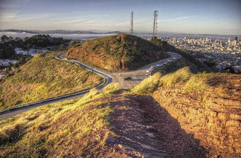
When locals need to impress visitors with San Francisco’s most spectacular views, they head to Twin Peaks—and for good reason. These two distinctive summits at 922 feet above sea level offer what many consider the most iconic panoramic view of San Francisco and the entire Bay Area, stretching from the Golden Gate Bridge to the East Bay hills, with downtown’s glittering skyline spread out below like an elaborate urban map.
What makes Twin Peaks particularly appealing for day hikers is its accessibility—you can experience those breathtaking 360-degree views with just a short 0.7-mile hike if you park near the summit, or turn it into a more substantial adventure by starting from Glen Canyon Park or other lower access points. The combination of easy access by car or public transit, family-friendly terrain, and absolutely unbeatable city views makes this one of San Francisco’s most beloved hiking destinations for both tourists and locals.
This trail is also featured in our Best Hiking Trails Near San Francisco for Day Hikers guide, where we highlight the top easy-to-moderate hikes that showcase the incredible diversity of outdoor adventures available within the Bay Area, from coastal walks to urban summits like this one.
Even though this is considered a short and relatively easy hike, the summit can be surprisingly windy and cold year-round—having a light windbreaker and good walking shoes makes all the difference between enjoying those spectacular views comfortably and shivering while trying to appreciate the scenery.
Why Hike Twin Peaks?
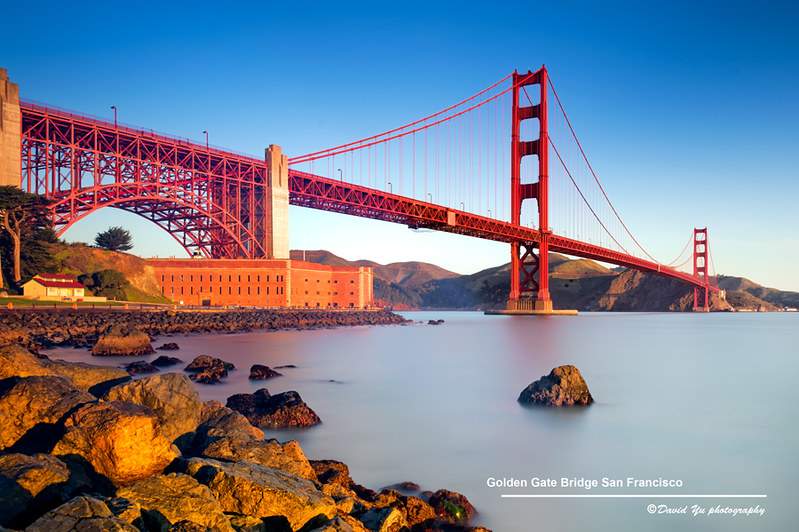
The 360° panoramic views from Twin Peaks are genuinely unmatched in San Francisco. From the north peak’s main viewing area, you’ll see the Golden Gate Bridge spanning majestically to the Marin Headlands, Alcatraz Island sitting like a fortress in the bay, downtown San Francisco’s evolving skyline with its mix of classic and modern architecture, the Bay Bridge stretching toward Oakland, and on clear days, views extending all the way to Mount Tamalpais in Marin County and Mount Diablo in the East Bay.
Accessibility makes this hike appealing to a remarkably broad range of people. Whether you choose the short summit loop from the parking area or longer approaches from Glen Canyon Park, the trails offer both paved and dirt path options that accommodate different mobility levels and hiking preferences. The fact that you can drive most of the way up means this spectacular viewpoint remains accessible to visitors who might not be able to handle longer or more strenuous hikes.
Twin Peaks has become San Francisco’s premier photography hotspot for both sunrise and sunset skyline shots. The elevated position and unobstructed views in multiple directions create ideal conditions for capturing the city’s dramatic light changes throughout the day—from morning fog rolling over the hills to the golden hour illuminating the downtown skyline to the twinkling city lights after dark.
The family and tourist friendly nature of this destination can’t be overstated. Kids are fascinated by the telescopes available at the main viewing area, and the variety of landmarks visible from the summit keeps everyone engaged while providing natural geography and history lessons about San Francisco and the Bay Area.
Quick Trail Snapshot
Duration30–45 minutes
| Feature | Details |
|---|---|
| Distance | 0.7 miles (summit loop) |
| Elevation | ~922 ft (peaks) |
| Difficulty | Easy |
| Best For | City views, photography |
| Dog-Friendly? | Yes (on leash) |
| Kid-Friendly? | Yes |
Trail Overview – What to Expect
Starting Point Options
The summit parking lot provides the most direct access to Twin Peaks’ famous views, allowing you to experience those panoramic vistas with minimal hiking effort. The main parking area at Christmas Tree Point offers coin-operated telescopes and the classic viewing platform where most of those iconic San Francisco photos are taken. From here, it’s just a short walk to reach the actual summit of either peak.
For those wanting a more substantial hiking experience, Glen Canyon Park and other longer approaches transform Twin Peaks into a more challenging adventure. The Creeks to Peaks Trail, for example, is a 1.8-mile moderate-to-strenuous route that connects Glen Canyon’s Islais Creek to Twin Peaks summit, providing 850 feet of elevation gain and a genuine workout while showcasing San Francisco’s diverse urban ecosystems.
Parking at the summit can be windy and cold even on warm days, so packing a compact backpack with snacks and extra layers is smart planning. The exposed location means weather conditions can change rapidly, and you’ll want to be comfortable while enjoying those spectacular views.
The Peaks – Eureka & Noe
The two summits, nicknamed “Eureka” and “Noe” after their respective neighborhoods, are connected by short dirt trails that lead to the actual high points of each peak. The trails are well-maintained with clear signage, benches for resting, and safety railings where needed, making navigation straightforward even for first-time visitors.
The north peak (Eureka) hosts the main parking area and primary viewing platform, while the south peak (Noe) tends to be less crowded and offers a slightly different perspective on the same spectacular scenery. Both summits provide those classic 360-degree views, but the south peak often feels more peaceful and less touristy, especially if you’re looking for a quieter spot to enjoy lunch or take photos.
Comfortable shoes with good grip are recommended since the dirt paths can become slippery after rain, and the elevation changes, while not extreme, do require some basic surefootedness. The trails are well-established, but San Francisco’s clay-rich soil can become muddy and slick during wet weather.
The Panoramic Views
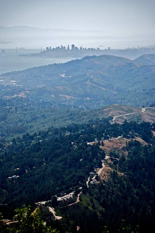
From Twin Peaks’ summits, you’ll see San Francisco’s most recognizable landmarks spread out in every direction. The Golden Gate Bridge dominates the northwestern view with the rolling hills of the Marin Headlands beyond, while the Bay Bridge spans eastward toward Oakland and the East Bay hills. Downtown San Francisco’s skyline, including the distinctive Transamerica Pyramid and Salesforce Tower, provides a constantly evolving urban landscape that changes with new construction.
The best times for photography are typically sunrise for those dramatic morning light shots of the downtown skyline, sunset for classic golden hour photography, and nighttime for spectacular city lights displays. Each time of day offers completely different photographic opportunities and moods, from morning fog effects to evening twilight magic.
For another hike with dramatic elevated views but a completely different forest setting, check out the Mount Davidson Trail, San Francisco’s actual highest point, which offers city panoramas from within peaceful eucalyptus groves rather than the exposed grassland environment of Twin Peaks.
Wildlife & Native Habitat Content
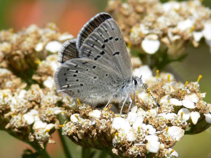
Twin Peaks serves as a 64-acre urban wilderness that provides crucial habitat for several rare and endangered species. The park contains some of the largest remaining areas of coastal scrub and native grassland within San Francisco, creating a natural oasis in the middle of the city that gives visitors a sense of how these hills looked before urban development.
The area is home to the federally endangered Mission Blue Butterfly, a spectacular species with iridescent blue wings that has adapted to the windy conditions by flying low to the ground from lupine plant to lupine plant. The butterfly’s presence here represents one of San Francisco’s most successful conservation stories—after nearly disappearing from Twin Peaks, a translocation program from San Bruno Mountain has helped reestablish a thriving population of an estimated 128 females as of 2023.
Seasonal wildflowers bloom throughout the grasslands, especially in spring when lupines, poppies, and other native plants create colorful displays that attract various bird species and butterflies. You might spot white-crowned sparrows, brush rabbits, and even occasional coyotes that have adapted to urban life in this preserved natural area.
Best Time to Visit Twin Peaks
Morning visits typically offer the clearest skies and best visibility before afternoon fog rolls in from the Pacific Ocean. If you’re hoping for those classic panoramic views with all the landmarks clearly visible, arriving between 8-10 AM generally provides the best conditions, especially during fall and winter months when fog is less frequent.
Sunset visits are the most popular but also the busiest time to experience Twin Peaks. The evening light creates spectacular photography conditions as the western sun illuminates the downtown skyline and reflects off the bay waters, but you’ll be sharing these views with many other visitors, particularly on weekends and during tourist season.
Night visits offer a completely different but equally magical experience, with the entire Bay Area spread out below as a glittering carpet of lights. The city lights, Bay Bridge illumination, and occasional events like fireworks create unique photographic opportunities, though you’ll want to bring a flashlight for navigating the trails and be prepared for significantly cooler temperatures.
Pack a lightweight windbreaker regardless of when you visit—Twin Peaks’ exposed position means the summit is almost always windy and can be 10-15 degrees cooler than street level, even on warm San Francisco days.
Tips for Hiking Twin Peaks
- Wear layers because the temperature difference between street level and the 922-foot summit can be dramatic, especially when coastal winds are blowing. A fleece jacket or windbreaker that can be easily packed away when not needed makes the difference between comfort and misery during those windy summit moments.
- Bring water and a snack since there are no facilities available on the trails themselves. A reusable water bottle or compact hydration pack helps maintain energy levels, especially if you’re doing the longer approaches from Glen Canyon Park or planning to spend time exploring both peaks and taking photos.
- Use AllTrails Pro or similar apps for navigation and route planning, especially if you’re interested in the less obvious approaches or want to combine Twin Peaks with other nearby trails. Having offline maps available ensures you won’t miss interesting detours or have trouble finding your way back to parking areas.
- Arrive early for parking since the main lot at Christmas Tree Point fills up quickly, especially on weekends and during peak tourist seasons. The lot is free, but spaces are limited, and street parking in the surrounding neighborhoods can be challenging to find.
- Photography gear should include a phone tripod or camera stabilizer for those perfect shots. The panoramic views and dramatic lighting conditions make Twin Peaks a photographer’s paradise, but having the ability to steady your camera significantly improves results, especially during golden hour or night photography.
Twin Peaks vs Other San Francisco Hikes
- Want more forested views? Try the Mount Davidson hike, which takes you through peaceful eucalyptus groves to San Francisco’s actual highest point at 928 feet. Mount Davidson offers a completely different hiking experience—quiet, shaded forest paths instead of exposed grassland, and city views framed by towering trees rather than the wide-open panoramas of Twin Peaks.
- Looking for coastal cliffside scenery? The Lands End Trail is a must-do coastal hike that combines Golden Gate Bridge views with dramatic Pacific Ocean cliffs, historic Sutro Baths ruins, and potential wildlife spotting along rugged shoreline paths. It’s a completely different perspective on San Francisco’s natural beauty—ocean drama instead of city panoramas.
- Prefer waterfront Golden Gate views? Walk the Crissy Field Promenade for a flat, family-friendly stroll along San Francisco Bay with constant Golden Gate Bridge views and plenty of amenities nearby. It’s the perfect complement to Twin Peaks’ elevated perspectives—offering bridge views from sea level instead of 900+ feet above.
Gear Checklist
- Daypack (lightweight, compact): You’ll want your hands free for navigating trails and taking photos, plus space for layers, water, and snacks. A small pack works perfectly for the short distances involved but makes the experience much more comfortable.
- Hiking shoes or trail runners: While the main viewing areas are paved, the actual summit trails involve dirt paths that can be uneven or slippery. Comfortable shoes with decent grip make a significant difference in both safety and enjoyment.
- Reusable water bottle or hydration bladder: Staying hydrated is important, especially during longer approaches or if you’re spending time exploring both peaks. The windy conditions can be surprisingly dehydrating.
- Windbreaker or fleece jacket: This might be the most important item on the list. Twin Peaks can be significantly windier and cooler than street level, and conditions can change rapidly throughout the day.
- Phone tripod or compact binoculars: The panoramic views and wildlife viewing opportunities are enhanced with the right accessories. A tripod helps with photography, while binoculars let you appreciate distant landmarks and spot birds or butterflies in the native grasslands.
Getting to Twin Peaks
By Car: The summit parking lot at Christmas Tree Point Road (100 Christmas Tree Point Road) provides the most convenient access. The lot is free but fills up quickly, especially on weekends. Since 2020, vehicle access is only available via Portola Drive to Twin Peaks Boulevard—the previous Clarendon Avenue access is permanently closed to cars.
By Public Transit: The 37-Corbett bus line provides the most direct public transit access, with stops on Crestline Drive near the base of the peaks. From there, it’s a moderate walk up to the summit areas. Other bus lines like the 48 and 52 stop on Portola Drive near the Twin Peaks turnoff, but require a longer uphill walk.
Walking Options: The Creeks to Peaks Trail connects Glen Canyon Park to Twin Peaks summit, offering a 1.8-mile moderate hiking experience that starts from more accessible transit locations. This route provides much more of a hiking workout while still delivering those spectacular summit views.
Accessibility notes: The main viewing area at Christmas Tree Point includes paved paths suitable for wheelchairs and strollers. However, reaching the actual summit of either peak requires navigating dirt trails and some elevation changes that may not be accessible to all mobility devices.
FAQs About the Twin Peaks Hike
- Is Twin Peaks safe? Yes, Twin Peaks is generally very safe during daylight hours with good visibility and regular foot traffic. The main safety considerations involve staying on marked trails, being prepared for windy conditions, and using normal urban hiking precautions like not leaving valuables visible in parked cars.
- Can you drive to the top? You can drive very close to the top via the Christmas Tree Point Road parking area, which puts you within a short walk of the main viewing platform. However, reaching the actual summits of either peak requires some walking on established trails.
- Is there parking? Yes, there’s free parking at the main Christmas Tree Point lot, plus a smaller lot between the two peaks that holds about 8 cars. Parking fills up quickly on weekends and during peak tourist seasons, so arriving early (before 9 AM) significantly improves your chances of finding a spot.
- Is the hike stroller/wheelchair friendly? The main viewing area at Christmas Tree Point is wheelchair and stroller accessible via paved paths. However, reaching the actual peak summits requires navigating dirt trails and elevation changes that may not be suitable for wheels.
- Can you bring dogs? Yes, dogs are allowed on leash throughout Twin Peaks. The native grassland habitat provides interesting sniffing opportunities for dogs, though owners should be aware that this is endangered butterfly habitat and should keep pets on designated trails.
Final Thoughts on the Twin Peaks Hike
Twin Peaks offers the perfect combination of accessibility and spectacular views that makes it one of San Francisco’s most beloved hiking destinations. Whether you’re looking for a quick 30-minute summit experience or a more substantial hiking adventure starting from lower elevations, you’ll be rewarded with genuinely unbeatable panoramic views that showcase the full geographic beauty of the San Francisco Bay Area—from Pacific Ocean to urban skyline to rolling East Bay hills.
The variety of approaches and difficulty levels means Twin Peaks works equally well for families with young children, tourists with limited time, serious photographers planning golden hour shoots, and local hikers who return regularly because the views never get old. Each visit can reveal different conditions—morning fog effects, dramatic sunset light, crystal clear winter air, or spring wildflower displays—making this a destination that rewards repeat visits throughout the year.
Explore more hikes that showcase San Francisco’s incredible diversity of outdoor experiences in our Best Hiking Trails Near San Francisco for Day Hikers guide, which includes everything from coastal adventures to urban summits to peaceful forest walks.
If you want higher elevation and a more forested hiking experience, try the Mount Davidson hike, which takes you through eucalyptus groves to the city’s actual highest point. If you prefer a coastal walk that combines history with ocean views, check out the Lands End Trail, which offers dramatic Pacific coastline scenery and fascinating historical sites just minutes from downtown San Francisco.


Leave a Reply