
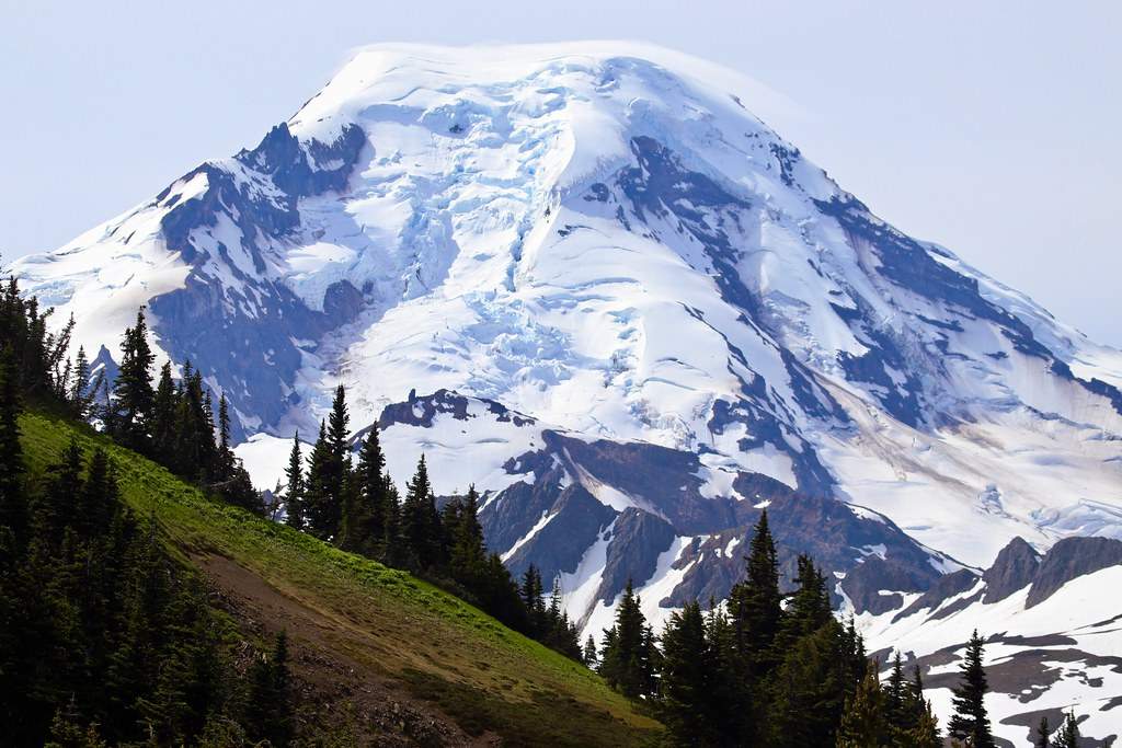
Skyline Divide stands as one of Washington’s most spectacular alpine ridge walks, offering hikers panoramic views of Mt. Baker’s glaciated north face and sweeping vistas that extend deep into the North Cascades. This moderate to strenuous day hike rewards those willing to tackle its steady climb with some of the most breathtaking mountain scenery in the Pacific Northwest. Perhaps what makes Skyline Divide truly special is the sense of walking along the spine of the mountains themselves—you’re literally hiking on a ridgeline with dramatic drop-offs and 360-degree views that feel more like something from the European Alps than a day hike accessible from Seattle.
This guide covers everything you need to know about hiking Skyline Divide, from detailed trail conditions and seasonal timing to essential gear recommendations and safety considerations. This guide is part of our Ultimate Day Hikes Near Me Washington, where we cover the best trails across the state for every skill level and interest.
Quick Trail Overview (Skyline Divide Facts)
- Distance: 9-10 miles round trip
- Elevation Gain: ~2,500 feet
- Difficulty: Moderate to strenuous
- Trailhead Location: Mt. Baker Ranger District (end of Forest Road 37)
- Best Season: Mid-July to early October (snow-free access)
- Family-friendly? Yes, but only for experienced young hikers comfortable with elevation and distance
- Dog policy: Yes, dogs allowed on leash (voice control acceptable in some areas)
Quick Comparisons
- For a shorter option with quick views, see our Mount Zion hike
- For another alpine adventure with glacier views, explore Panhandle Gap at Mt. Rainier
Important Note:
As of 2024, Forest Road 37 remains closed at mile 3.1 due to flood damage from 2021, making the trailhead currently inaccessible by vehicle. Check current road conditions before planning your trip, as repair timelines remain uncertain.
Getting to the Trailhead
- From Seattle (2.5 hours): Take I-5 north to Bellingham, then follow State Route 20 east to SR-9 north. Continue to SR-542 (Mount Baker Highway) east through Glacier.
- From Bellingham (1.5 hours): Take SR-542 (Mount Baker Highway) east approximately 33 miles to Glacier.
Key Directions:
From Glacier, drive east on Mount Baker Highway 542 for approximately 1 mile past the Glacier Public Service Center to Glacier Creek Road (Forest Service Road 39). Turn right onto FS Road 39, then immediately left onto Deadhorse Road (Forest Service Road 37). Under normal conditions, this rough dirt road continues 12.7 miles to the trailhead parking area.
Road Conditions:
Forest Road 37 deserves its reputation as one of the rougher access roads in the North Cascades. Even when open, expect deep potholes, washboard sections, and steep switchbacks that require slow, careful driving. High-clearance vehicles are strongly recommended, though determined drivers have managed the route in regular cars. Plan 45-60 minutes for the road portion alone.
Parking & Permits:
The trailhead parking area accommodates roughly 20 vehicles, so early arrival is crucial during peak season. A Northwest Forest Pass is required—we recommend keeping an annual NW Forest Pass if you hike often, as it saves money and works at numerous Washington trailheads throughout the region.
Trail Experience – Step by Step
The Forest Ascent
The Skyline Divide trail starts with perhaps the most challenging section—a relentless climb through dense forest that gains roughly 1,500 feet in the first two miles. The path winds through towering Pacific silver fir, western hemlock, and Alaska yellowcedar, creating a fairy-tale forest atmosphere with branches draped in lush moss. While beautiful, this section can feel like a grind, especially during peak bug season in July and August when biting insects are abundant.
The trail follows well-maintained switchbacks, but don’t underestimate the sustained nature of this climb. You’re gaining about 750 feet per mile, which qualifies as steep by most standards. Take your time, maintain a steady pace, and remember that the payoff ahead justifies every step.
Breaking Out to the Alpine Meadow
After approximately two miles of forest climbing, the trail breaks into Mt. Baker Wilderness and the first spectacular alpine meadows appear. This moment ranks among the most dramatic trail transitions in Washington—you emerge from dense forest into vast wildflower meadows with Mt. Baker’s glaciated north face dominating the southern horizon.
This is where trekking poles make a huge difference, both for the uneven meadow terrain and for the steep sections still to come. The elevation here sits around 5,800 feet, and you’ve officially entered the high alpine environment where weather can change rapidly.
Ridge Walking & Panoramic Views
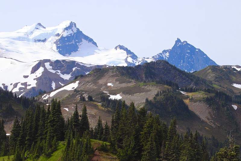
The trail continues south along the actual ridge divide, offering continuous panoramic views in all directions. To the south, Mt. Baker’s 10,781-foot summit appears close enough to touch, its Roosevelt and Boulder glaciers cascading down the north face. East brings views of Mt. Shuksan’s dramatic pyramid, while north extends views into Canada and the High Divide.
The ridgeline section involves climbing over a series of six rolling knolls or bumps, each offering slightly different perspectives and photo opportunities. These ups and downs add roughly another 500 feet of elevation gain beyond the initial forest climb, but the incredible scenery makes each step worthwhile.
Optional trail spurs lead to established camping areas for backpackers, but day hikers typically continue south along the main ridge toward Mt. Baker. The trail eventually reaches about 6,200 feet at its highest practical turnaround point for most day hikers.
Wildlife & Flora
Skyline Divide’s diverse ecosystem supports abundant wildlife and spectacular wildflower displays. Marmots are common sightings, often heard whistling from rocky outcrops before you spot them. Mountain goats occasionally appear on distant ridges, and deer frequent the meadow edges, particularly in early morning or late afternoon.
The wildflower displays rank among Washington’s finest. Peak blooming typically occurs from late July through August, with lupine, Indian paintbrush, mountain heather, valerian, and beargrass creating spectacular color displays. Early season (July) features glacier lilies in recently melted areas, while late season brings brilliant fall colors to the meadow grasses and alpine foliage.
Best Time to Hike Skyline Divide

Summer Peak Season (Mid-July to August):
This represents the ideal time for Skyline Divide, when trails are snow-free, wildflowers reach peak bloom, and weather is most stable. July offers the most dramatic wildflower displays, particularly the pink mountain heather that typically peaks between July 15-25. August provides the most reliable weather and fully accessible trails, though crowds peak during this period.
Early Fall (September to Early October):
Fall hiking on Skyline Divide offers several advantages: fewer crowds, crisp air, stable weather, and the beginning of fall color changes in the meadow grasses and alpine vegetation. September often provides the best overall hiking conditions—clear weather without peak summer crowds.
Spring/Early Summer Cautions:
Snow lingers on Skyline Divide well into July most years, and avalanche danger remains significant during shoulder seasons. Even in mid-July, expect possible snow patches on north-facing slopes and prepare accordingly.
For a fall color hike closer to I-90 that doesn’t require such a long drive, check out Kendall Katwalk, which offers excellent larch viewing and easier access from Seattle.
What to Pack for Skyline Divide
Footwear
Waterproof Hiking Boots vs. Trail Runners:
Skyline Divide’s alpine meadow environment and potential for wet conditions make waterproof boots the safer choice for most hikers. The trail crosses several creek areas, meadows can be boggy even in summer, and morning dew soaks vegetation well into the day. Boots also provide better ankle support on the uneven ridgeline terrain and rocky sections near the trail’s end.
Quality waterproof boots with aggressive tread work best—think Salomon X Ultra or Merrell Moab models that balance waterproofing with breathability. However, experienced hikers comfortable with potentially wet feet might prefer lightweight trail runners for their superior comfort on the long ridge walks.
Hiking Gear Essentials
- Trekking Poles: Consider trekking poles essential rather than optional for Skyline Divide. The steep forest descent on the return trip puts significant stress on knees and ankles, while the ridgeline’s uneven terrain and occasional scrambling sections benefit from the extra stability poles provide.
- Daypack (20-30L): A mid-sized daypack handles Skyline Divide’s requirements comfortably. You’ll need space for extra layers, rain protection, substantial food and water, and safety equipment without the pack feeling cumbersome during the long ridge walk.
- Hydration System: Carry 2-3 liters of water minimum, with more in hot weather or if you’re a heavy sweater. No reliable water sources exist along the ridge itself, though early season may offer snowmelt in some areas. Hydration bladders work well for steady drinking during the long climbs.
- Navigation: Download offline maps (AllTrails, Gaia GPS) before leaving home, as cell service is nonexistent in most areas. The main trail is well-established, but the various spurs to camping areas and the optional extensions toward Chowder Ridge require careful navigation.
Clothing & Layering
- Rapid Weather Changes: Mt. Baker’s proximity creates its own weather patterns, and conditions can shift from sunny and warm to cold and windy within minutes. A three-layer system handles most conditions: moisture-wicking base layer, insulating mid-layer (fleece or lightweight down), and waterproof shell jacket.
- Essential Shell Layer: A lightweight rain jacket deserves priority space in your pack. Even on seemingly perfect days, afternoon clouds can bring sudden showers or wind that make waterproof protection crucial for comfort and safety.
Food & Hydration
- Energy Requirements: Skyline Divide’s 9-10 mile distance and 2,500 feet of elevation gain demand substantial fuel. Pack high-calorie snacks like nuts, energy bars, and dried fruit, plus a substantial lunch to enjoy during your ridge-top break.
- Electrolyte Considerations: The combination of elevation, sun exposure, and sustained effort makes electrolyte replacement important. Consider electrolyte mixes or tablets, particularly during hot weather when sweating increases significantly.
Water filters aren’t necessary for day hiking, but if you’re considering extending into backpacking, collapsible water filters allow you to take advantage of seasonal streams and snowmelt.
Tips for a Great Skyline Divide Hike
- Start Early: Parking fills quickly during peak season, and afternoon thunderstorms become more likely later in the day. Aim to reach the trailhead by 7:00 AM during peak season, even earlier on weekend days. Early starts also provide better light for photography and wildlife viewing.
- Weather Vigilance: Mt. Baker’s weather can shift rapidly and dramatically. Check forecasts not just for the trailhead elevation, but for higher elevations where conditions may differ significantly. Be prepared to turn back if conditions deteriorate—the mountains will be there for another attempt.
- Photography Opportunities: Skyline Divide offers exceptional photography throughout the day, but golden hour lighting (early morning or late evening) transforms the wildflower meadows and Mt. Baker views into something truly magical. Consider the long summer daylight hours if you want to capture sunset lighting.
If you want another ridge hike with dramatic scenery and perhaps slightly less demanding access, don’t miss Dirty Harry’s Peak, which offers stunning views from the I-90 corridor with a more straightforward approach.
Permits, Safety & Leave No Trace
Northwest Forest Pass Required:
All vehicles parking at Skyline Divide require a valid Northwest Forest Pass ($5 daily or $30 annual). Annual passes represent excellent value for frequent hikers, as they work at dozens of trailheads throughout Washington’s national forests.
Leave No Trace in Fragile Alpine Meadows:
Skyline Divide’s alpine meadows are particularly vulnerable to damage from foot traffic and camping. Stay on established trails at all times, even when they’re wet or muddy. Take breaks and photos from durable surfaces like rocks or established rest spots rather than trampling through flower displays.
The growing popularity of Skyline Divide has led to some meadow damage in recent years, making careful Leave No Trace practices essential for preserving this spectacular destination for future visitors.
Safety Essentials:
Bring navigation tools (map, compass, GPS), first aid kit, extra food and water, and emergency shelter. The remote location means help could be hours away in case of emergency. Consider carrying a personal locator beacon or satellite communicator for serious safety margin.
Weather-related hazards include sudden storms, temperature drops, and potential for snow even in summer. Afternoon thunderstorms can bring dangerous lightning to the exposed ridge areas.
Alternative Trails to Skyline Divide
- For Easier Hikes: If Skyline Divide feels too demanding, Mount Zion Trail offers spectacular Olympic Mountain views with significantly less elevation gain and distance.
- For Tougher Alpine Challenges: Experienced hikers seeking more demanding adventures should consider Big Heart Lake, which offers pristine alpine lake destinations in the deeper wilderness.
- For Mount Rainier Views: Panhandle Gap provides the ultimate Mount Rainier National Park day hiking experience, with glacier views and high alpine terrain.
Conclusion – Is Skyline Divide Right for You?
Skyline Divide delivers one of Washington’s most spectacular day hiking experiences, combining moderate effort with truly exceptional alpine rewards. The combination of wildflower meadows, panoramic mountain views, and genuine ridgeline walking creates memories that last a lifetime. While the approach requires commitment—both in terms of physical preparation and navigating access challenges—few Washington day hikes offer comparable scenic payoffs.
This trail suits hikers comfortable with sustained elevation gain, longer distances, and potentially challenging road access. The rewards justify the effort for those prepared for a serious mountain adventure.
This is just one of the many unforgettable trails we’ve included in our Washington Day Hikes Guide, which covers spectacular hiking throughout the state from beginner-friendly forest walks to challenging alpine adventures.
Before you go, make sure you’re equipped with the gear we’ve recommended above—waterproof boots, trekking poles, proper layers, and navigation tools can make the difference between a good hike and an unforgettable mountain adventure. The incredible views from Skyline Divide’s ridgeline await, and there’s nothing quite like standing on the spine of the North Cascades with Mt. Baker towering nearby.


Leave a Reply