

Panhandle Gap stands as the crown jewel of day hikes in Mount Rainier National Park, representing the highest point on the famous Wonderland Trail that hikers can reasonably reach in a single day. At 6,800 feet elevation, this spectacular alpine destination delivers everything that makes Mount Rainier legendary: glacial moraines, pristine alpine meadows, abundant wildlife, and commanding views that stretch across the Cascade Range from Mount Adams to the distant peaks of the North Cascades. Perhaps what makes Panhandle Gap truly special is the complete mountain experience it provides—old-growth forests give way to wildflower meadows before transitioning into the harsh, beautiful world of rock, ice, and endless sky.
Located in the White River area of Mount Rainier National Park, Panhandle Gap represents one of the most demanding but rewarding day hikes accessible from Seattle. This trail is part of our Ultimate Day Hikes Near Me (Washington Edition), where we cover Washington’s most iconic day hikes for every skill level and adventure goal.
Panhandle Gap Trail Overview (Quick Facts)
- Distance: ~10.5-11 miles round trip (via Summerland)
- Elevation Gain: ~2,600-3,000 feet
- Difficulty: Strenuous
- Location: Mount Rainier National Park, White River/Sunrise area
- Trail Type: Out-and-back on Wonderland Trail
- High Point: 6,800 feet (highest point on Wonderland Trail)
- Family-friendly? Only for experienced teens and adults with strong hiking backgrounds
- Dog policy: Dogs not allowed in National Park
Quick Comparisons
- If you want a shorter beginner-friendly trail, check out Mount Zion
- For another alpine ridge adventure with wildflower meadows, see Skyline Divide
Important 2025 Update:
Beginning July 11, 2025, vehicles entering the White River/Sunrise Corridor require timed entry reservations between 7:00 AM and 5:00 PM daily through September 1, then weekends and holidays only through mid-October. Plan ahead and book your reservation at Recreation.gov.
Getting to the Trailhead
- From Seattle (~2 hours): Take I-5 south to State Route 18 east, then SR-164 to SR-410 east through Enumclaw. Continue on SR-410 to the Mount Rainier National Park White River Entrance. From the entrance station, continue 3 miles on White River Road to the Fryingpan Creek Trailhead, located just past the bridge over Fryingpan Creek.
Trailhead Location:
The Summerland trailhead sits at 3,900 feet elevation with a small parking area that accommodates roughly 20-30 vehicles. This is one of the most popular trailheads in Mount Rainier National Park, so arriving early is crucial.
Parking Strategy:
Plan to arrive by 7:00-8:00 AM during peak season (July-September) to secure parking. The lot fills completely on weekends and often by mid-morning on weekdays during summer months. No facilities exist at the trailhead—use restrooms at White River Campground if needed.
Permits Required:
Mount Rainier National Park entrance fee ($30 per vehicle for 7 days) or annual passes required. Save money with an annual America the Beautiful Pass ($80), which covers all National Parks and many other federal recreation sites. Additionally, timed entry reservations are mandatory during peak hours in 2025—book in advance at Recreation.gov.
The Trail Experience – Step by Step
Fryingpan Creek Ascent (Miles 0-3.2)
The Panhandle Gap trail begins as a gentle walk through magnificent old-growth forest at 3,900 feet elevation. For the first mile, the trail remains nearly level as it parallels Fryingpan Creek through towering Douglas fir, western hemlock, and Pacific silver fir. This peaceful beginning provides excellent opportunities to spot shade-tolerant wildflowers like queen’s cup, coral root, and sidebells pyrola.
The trail gradually steepens as you continue through the forest, crossing occasional small streams and offering glimpses of Fryingpan Creek rushing through narrow rocky gorges below the trail. Around mile 2, you’ll notice the trail becoming more sustained in its upward progression, though still manageable for most hikers in good condition.
At 3.2 miles, the trail crosses Fryingpan Creek via a bridge—this marks the transition from easy forest walking to more serious mountain hiking. Important Note: As of late 2024, the upper Fryingpan Creek bridge between Summerland and Panhandle Gap washed out and requires careful rock-hopping or potentially dangerous fording. Check current trail conditions at the National Park Service website before attempting this hike.
Summerland Meadows (Miles 3.2-4.2)
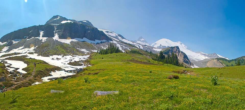
After crossing Fryingpan Creek, the forest begins opening up and the trail climbs more steeply through a series of switchbacks. Around mile 4, you emerge into one of Mount Rainier’s most famous and photographed destinations: Summerland.
Summerland represents the perfect alpine meadow—expansive wildflower fields framed by towering peaks, with Mount Rainier’s glaciated bulk dominating the southern horizon. The meadows burst with color from mid-July through August, featuring lupine, paintbrush, heather, columbine, and dozens of other alpine species. This is also prime habitat for Olympic marmots, which are often seen (and heard) throughout the area.
The Summerland backcountry camp sits at 5,900 feet and features one of the most developed campsites on the Wonderland Trail, including a historic stone shelter built by the Civilian Conservation Corps during the Great Depression. Day hikers can use this as an excellent rest stop and turnaround point for those not continuing to Panhandle Gap.
Climbing to Panhandle Gap (Miles 4.2-5.5)
Beyond Summerland, the trail character changes dramatically as you enter the true alpine zone. Vegetation becomes sparse, replaced by a landscape of rock, ice, and glacial moraines. The final 1.3 miles to Panhandle Gap gain roughly 900 feet of elevation, making this the most demanding section of the hike.
Snow patches persist well into August and sometimes into September on north-facing slopes and shaded areas. The trail becomes less obvious in this rocky terrain—watch for rock cairns and stay alert for the proper route. This is where trekking poles and potentially microspikes become especially valuable for stability and traction on steep, potentially icy surfaces.
Water becomes abundant in this section from snowmelt streams and small tarns. Look for the distinctive turquoise and green alpine lakes that form as snow melts—these provide spectacular photography opportunities and serve as landmarks for navigation.
At the Gap – Highest Point on Wonderland Trail (Mile 5.5)
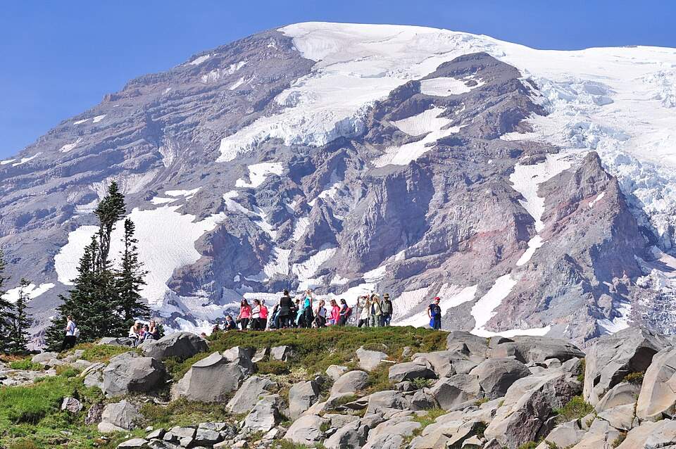
Panhandle Gap itself sits at 6,800 feet and represents the absolute highest point on the entire 93-mile Wonderland Trail. The gap provides a dramatic saddle between Little Tahoma Peak and the Cowlitz Chimneys, opening views south toward Mount Adams and the Goat Rocks, plus expansive panoramas across Ohanapecosh Park and the Cascades beyond.
The final approach to the gap often involves crossing a steep snowfield that may persist into late summer. Use extreme caution here—the snowfield sits above a dangerous runout of rocks, and falls could be serious. If conditions look unsafe, don’t hesitate to turn back from a viewpoint just below the gap.
Wildlife sightings commonly include mountain goats, marmots, pikas, and occasionally black bears. The gap provides an excellent lunch spot and turnaround point for most day hikers, though the Wonderland Trail continues south toward Indian Bar for those with extra energy and time.
Best Time to Hike Panhandle Gap
Mid-July to September: Prime Season
The best window for Panhandle Gap typically opens in mid-July when snow clears from most of the trail and dangerous avalanche conditions subside. Peak wildflower displays in Summerland occur from late July through August, while September often provides the most stable weather with fewer crowds.
Early Season Hazards (May-July)
Spring and early summer present significant dangers on this high-elevation trail. Snow lingers late into the season, creating avalanche hazards and making navigation difficult. Stream crossings become dangerous during peak snowmelt, and the final approach to the gap may remain impassable until mid-July in heavy snow years.
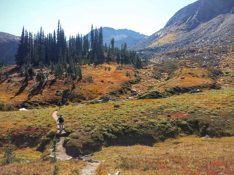
Late Summer/Fall (August-October)
Late summer through early fall represents the safest and most rewarding time for this hike. Snow has largely melted, wildflowers are at their peak, weather is most stable, and wildlife is active. September and early October often provide crystal-clear mountain views and comfortable hiking temperatures.
For another high-alpine summer ridge experience with similar wildflower displays, see Kendall Katwalk along the Pacific Crest Trail. For colorful meadows in a different setting, explore Skyline Divide near Mount Baker.
What to Pack for Panhandle Gap
Footwear
Sturdy Hiking Boots Essential
Panhandle Gap’s demanding terrain, potential snow crossings, and steep rocky sections make sturdy hiking boots with ankle support non-negotiable for most hikers. The trail involves everything from forest floors to rocky moraines to potentially icy snowfields—boots provide the stability, protection, and traction needed for safe passage.
Quality waterproof hiking boots handle the numerous stream crossings, morning dew on vegetation, and potential snow patches while providing the ankle support that proves crucial during the long descent on fatigued legs. Look for boots with aggressive tread patterns for traction on both wet rock and potentially icy surfaces.
Optional: Trail Crampons
Consider lightweight trail crampons or microspikes for early season hiking or any time snow patches are expected. Even small amounts of snow or ice can make granite surfaces extremely dangerous—having traction devices provides crucial safety margin during potentially hazardous crossings.
Daypack & Hydration
- 30L Pack with Hydration System: The 11-mile distance and strenuous elevation gain require a larger daypack than shorter hikes—aim for 30 liters capacity to accommodate water, food, extra layers, and safety equipment. You’ll need space for potentially overnight emergency gear, as weather can change rapidly in the high alpine environment.
- Carry 2-3 Liters Water Minimum: The combination of distance, elevation gain, and potential for hot conditions demands serious attention to hydration. Carry 2-3 liters minimum, with more during hot weather or if you’re a heavy sweater. Multiple water sources exist along the trail for filtering additional water if needed.
Water filters or purification tablets become valuable for extending your water supply from the numerous streams and tarns, particularly if you plan to explore beyond the gap or if conditions are warmer than expected.
Trekking Poles & Safety Gear
- Poles Essential for Rocky Terrain: Trekking poles prove invaluable for Panhandle Gap, both for stability during steep rocky climbs and for balance during potentially dangerous stream crossings. They’re particularly important for the long descent when leg fatigue makes stability crucial for safety.
- Navigation Requirements: GPS devices or offline maps (Gaia GPS, AllTrails) become essential above Summerland where the trail can be difficult to follow in rocky terrain. Cell service is nonexistent in most areas, making downloaded maps crucial for safe navigation.
Clothing & Weather Readiness
- Layering System Critical: Mount Rainier’s weather changes rapidly and dramatically, particularly at the 6,800-foot elevation of Panhandle Gap. A comprehensive layering system—base layer, insulating mid-layer, and waterproof shell—handles conditions from warm valley floors to potentially freezing temperatures and sudden storms at elevation.
- Packable Rain Jacket Essential: Never attempt Panhandle Gap without waterproof rain protection. Afternoon thunderstorms develop quickly, and the exposed nature of the gap provides no shelter from sudden weather changes. Quality packable rain jackets take minimal pack space while providing crucial protection.
Food & Energy Requirements
- High-Calorie Snacks and Lunch: The strenuous nature of this hike demands substantial fuel—pack high-calorie snacks like nuts, energy bars, and dried fruit, plus a satisfying lunch to enjoy at the gap. The 11-mile distance and 3,000 feet of elevation gain burn significant calories.
- Electrolyte Replacement: Consider electrolyte mixes or tablets, particularly during hot weather when sweating increases significantly. The combination of elevation, sustained effort, and sun exposure makes electrolyte balance important for maintaining energy and preventing cramping.
Tips for a Great Panhandle Gap Hike
- Start Early for Multiple Reasons: Plan to reach the trailhead by 7:00 AM during peak season for several crucial reasons: securing parking (the lot fills completely), avoiding afternoon thunderstorms (common in the high alpine), and allowing adequate time for the long hike without feeling rushed.
- Weather Monitoring Essential: Check detailed weather forecasts not just for the trailhead elevation, but for higher elevations where conditions can differ dramatically. Mount Rainier creates its own weather patterns, and conditions at 6,800 feet may be completely different from valley forecasts.
- Wildlife Awareness and Ethics: Panhandle Gap offers excellent wildlife viewing opportunities, but never feed marmots, mountain goats, or any other animals. Feeding wildlife creates dangerous situations and disrupts natural behaviors. Keep food secure and observe animals from appropriate distances.
If you want a remote alpine lake experience that’s even more challenging, check out Big Heart Lake, which offers pristine wilderness destinations in the Alpine Lakes area. For a nearby training hike along the I-90 corridor that builds fitness for bigger objectives, try Dirty Harry’s Peak.
Wildlife, Flora & Photography
- Wildflower Spectacle: Summerland’s wildflower displays rank among the finest in Mount Rainier National Park. Peak blooming occurs from late July through August, featuring lupine, Indian paintbrush, mountain heather, columbine, penstemon, monkey flower, and dozens of other alpine species. The diversity and density of flowers create spectacular photography opportunities throughout the meadow section.
- Alpine Wildlife: Mountain goats frequent the Panhandle Gap area and may be observed on surrounding cliffs and rocky slopes. Olympic marmots are common throughout Summerland and often provide entertaining photo subjects as they sun themselves on rocks or interact with each other. Pikas inhabit the talus fields, and black bears occasionally pass through the area.
- Photography Opportunities: The trail offers exceptional photography from sunrise lighting at Summerland through panoramic mountain shots at the gap itself. The turquoise alpine tarns below the gap provide particularly striking subjects, especially with Mount Rainier reflected in their still waters. Golden hour lighting transforms both the wildflower meadows and rocky alpine terrain.
Consider ultralight DSLR setups or phone camera tripods for capturing both intimate flower details and sweeping landscape panoramas. The exposed nature of the gap allows for dramatic lighting effects throughout the day.
Permits, Safety & Leave No Trace
- National Park Requirements: Mount Rainier National Park entrance fees are required ($30 per vehicle for 7 days, or various annual passes). No additional permits are needed for day hiking to Panhandle Gap, though wilderness permits are required for overnight camping at Summerland or beyond.
- 2025 Timed Entry System: Beginning July 11, 2025, vehicles entering the White River/Sunrise Corridor require advance timed entry reservations between 7:00 AM and 5:00 PM. Book reservations at Recreation.gov starting 90 days in advance. Early morning (before 7:00 AM) or evening (after 5:00 PM) arrivals don’t require reservations.
- High Alpine Safety: Panhandle Gap presents serious mountain hazards including snow travel, stream crossings, exposure, and rapidly changing weather. Carry comprehensive safety equipment including navigation tools, first aid supplies, emergency shelter, and extra food and water. The remote location means rescue could take many hours even in good conditions.
- Protecting Fragile Meadows: Summerland’s alpine meadows are extremely fragile and slow to recover from damage. Stay on established trails at all times, even when wet or muddy. Avoid walking through flower displays for photos—use designated rest areas and established viewpoints. Pack out all trash and never pick flowers or disturb wildlife.
Alternative Hikes to Panhandle Gap
- For Easier Options: Mount Zion provides spectacular mountain views with significantly less elevation gain and distance, making it perfect for families or those not ready for Panhandle Gap’s demands.
- For Moderate Ridgeline Experience: Kendall Katwalk offers famous granite ledge walking with excellent views and a more moderate approach than Panhandle Gap.
- For Remote Alpine Lakes: Big Heart Lake provides pristine wilderness destinations for those seeking even more challenging and remote alpine adventures.
- For Spectacular Ridge Walking: Skyline Divide near Mount Baker delivers incredible ridge hiking with panoramic mountain views and spectacular wildflower displays.
Conclusion – Is Panhandle Gap Washington’s Best Day Hike?
Panhandle Gap delivers one of Washington’s most complete and rewarding alpine hiking experiences, combining the best elements of Mount Rainier National Park into a single, challenging adventure. The progression from old-growth forests through wildflower meadows to harsh alpine terrain showcases the incredible diversity that makes the Pacific Northwest legendary for hiking.
This trail demands serious preparation, good fitness, and respect for the mountain environment, but rewards those efforts with memories that last a lifetime. Standing at 6,800 feet on the highest point of the Wonderland Trail, surrounded by glaciated peaks and endless wilderness, you’ll understand why Mount Rainier draws hikers from around the world.
Panhandle Gap is just one of many incredible hikes featured in our Washington Day Hikes Guide—explore the full list to find the perfect trail for your next adventure, whether you’re seeking shorter family-friendly options or challenging full-day alpine experiences.
Before you go, make sure you’re geared up with sturdy waterproof boots, trekking poles for stability and stream crossings, and a reliable 30L pack with adequate water capacity. Most importantly, secure your timed entry reservation in advance and check current trail conditions, as bridge outages and snow conditions can significantly impact your hiking experience. The incredible alpine world of Panhandle Gap awaits those prepared to meet its challenges safely.


Leave a Reply